Cirkit Designer Logo
Cirkit Designer
Your all-in-one circuit design IDE
Home / 
Component Documentation

How to Use GNSS L86: Examples, Pinouts, and Specs

Image of GNSS L86
Cirkit Designer LogoDesign with GNSS L86 in Cirkit Designer

Introduction

The GNSS L86, manufactured by Quectel (Part ID: L86-M33), is a compact and high-performance Global Navigation Satellite System (GNSS) receiver module. It supports multiple satellite systems, including GPS, GLONASS, and BeiDou, enabling accurate positioning and timing information. Designed for low power consumption, the L86 is ideal for portable and battery-operated devices.

Explore Projects Built with GNSS L86

Use Cirkit Designer to design, explore, and prototype these projects online. Some projects support real-time simulation. Click "Open Project" to start designing instantly!
ESP32-Based GPS Tracker with OLED Display and Firebase Integration
Image of ecs: A project utilizing GNSS L86 in a practical application
This circuit is a GPS tracking system that uses an ESP32 microcontroller to read location data from a NEO-6M GPS module and display information on a 0.96" OLED screen. The system is powered by a 2000mAh battery with a lithium-ion charger, and it uploads the GPS data to Firebase via WiFi. Additional components include an MPU6050 accelerometer/gyroscope for motion sensing and a buzzer for alerts.
Cirkit Designer LogoOpen Project in Cirkit Designer
ESP32-Based GPS Tracker with OLED Display and Telegram Integration
Image of Yoon: A project utilizing GNSS L86 in a practical application
This circuit is a GPS-based tracking system that uses an ESP32 microcontroller to receive GPS data from a NEO 6M module and display the coordinates on a 1.3" OLED screen. It also features WiFi connectivity to send location updates to a remote server, potentially for applications such as asset tracking or navigation assistance.
Cirkit Designer LogoOpen Project in Cirkit Designer
Arduino Nano Based GPS Tracker with GSM Communication and Accelerometer
Image of Circuit Aayush: A project utilizing GNSS L86 in a practical application
This circuit is designed for communication and location tracking purposes. It features an Arduino Nano interfaced with a SIM800L GSM module for cellular connectivity, a GPS NEO 6M module for obtaining geographical coordinates, and an AITrip ADXL335 GY-61 accelerometer for motion sensing. The LM2596 Step Down Module is used to regulate the power supply to the components.
Cirkit Designer LogoOpen Project in Cirkit Designer
Satellite Compass and Network-Integrated GPS Data Processing System
Image of GPS 시스템 측정 구성도_241016: A project utilizing GNSS L86 in a practical application
This circuit comprises a satellite compass, a mini PC, two GPS antennas, power supplies, a network switch, media converters, and an atomic rubidium clock. The satellite compass is powered by a triple output DC power supply and interfaces with an RS232 splitter for 1PPS signals. The mini PCs are connected to the USRP B200 devices via USB for data and power, and to media converters via Ethernet, which in turn connect to a network switch using fiber optic links. The antennas are connected to the USRP B200s through RF directional couplers, and the atomic clock provides a 1PPS input to the RS232 splitter.
Cirkit Designer LogoOpen Project in Cirkit Designer

Explore Projects Built with GNSS L86

Use Cirkit Designer to design, explore, and prototype these projects online. Some projects support real-time simulation. Click "Open Project" to start designing instantly!
Image of ecs: A project utilizing GNSS L86 in a practical application
ESP32-Based GPS Tracker with OLED Display and Firebase Integration
This circuit is a GPS tracking system that uses an ESP32 microcontroller to read location data from a NEO-6M GPS module and display information on a 0.96" OLED screen. The system is powered by a 2000mAh battery with a lithium-ion charger, and it uploads the GPS data to Firebase via WiFi. Additional components include an MPU6050 accelerometer/gyroscope for motion sensing and a buzzer for alerts.
Cirkit Designer LogoOpen Project in Cirkit Designer
Image of Yoon: A project utilizing GNSS L86 in a practical application
ESP32-Based GPS Tracker with OLED Display and Telegram Integration
This circuit is a GPS-based tracking system that uses an ESP32 microcontroller to receive GPS data from a NEO 6M module and display the coordinates on a 1.3" OLED screen. It also features WiFi connectivity to send location updates to a remote server, potentially for applications such as asset tracking or navigation assistance.
Cirkit Designer LogoOpen Project in Cirkit Designer
Image of Circuit Aayush: A project utilizing GNSS L86 in a practical application
Arduino Nano Based GPS Tracker with GSM Communication and Accelerometer
This circuit is designed for communication and location tracking purposes. It features an Arduino Nano interfaced with a SIM800L GSM module for cellular connectivity, a GPS NEO 6M module for obtaining geographical coordinates, and an AITrip ADXL335 GY-61 accelerometer for motion sensing. The LM2596 Step Down Module is used to regulate the power supply to the components.
Cirkit Designer LogoOpen Project in Cirkit Designer
Image of GPS 시스템 측정 구성도_241016: A project utilizing GNSS L86 in a practical application
Satellite Compass and Network-Integrated GPS Data Processing System
This circuit comprises a satellite compass, a mini PC, two GPS antennas, power supplies, a network switch, media converters, and an atomic rubidium clock. The satellite compass is powered by a triple output DC power supply and interfaces with an RS232 splitter for 1PPS signals. The mini PCs are connected to the USRP B200 devices via USB for data and power, and to media converters via Ethernet, which in turn connect to a network switch using fiber optic links. The antennas are connected to the USRP B200s through RF directional couplers, and the atomic clock provides a 1PPS input to the RS232 splitter.
Cirkit Designer LogoOpen Project in Cirkit Designer

Common Applications

  • Personal navigation devices
  • Wearable technology
  • Asset tracking systems
  • IoT applications requiring precise location data
  • Automotive navigation and fleet management
  • Timing synchronization for communication systems

Technical Specifications

Key Technical Details

Parameter Specification
Manufacturer Quectel
Part ID L86-M33
Satellite Systems GPS, GLONASS, BeiDou
Positioning Accuracy 2.5 meters CEP (Circular Error Probable)
Time to First Fix (TTFF) Cold Start: 35s, Hot Start: 1s
Operating Voltage 2.8V to 4.3V
Power Consumption 20mA (tracking mode)
Operating Temperature -40°C to +85°C
Dimensions 16.0mm × 16.0mm × 6.45mm
Communication Interface UART, I2C

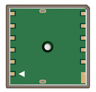
Pin Configuration and Descriptions

Pin Number Pin Name Description
1 VCC Power supply input (2.8V to 4.3V)
2 GND Ground
3 TXD UART Transmit Data
4 RXD UART Receive Data
5 PPS Pulse Per Second output for timing
6 SDA I2C Data Line
7 SCL I2C Clock Line
8 ANT_IN External antenna input

Usage Instructions

How to Use the GNSS L86 in a Circuit

  1. Power Supply: Connect the VCC pin to a stable power source (2.8V to 4.3V) and the GND pin to the ground of the circuit.
  2. Communication Interface:
    • For UART communication, connect the TXD and RXD pins to the corresponding UART pins of your microcontroller.
    • For I2C communication, connect the SDA and SCL pins to the I2C bus of your microcontroller.
  3. Antenna: Attach an external active antenna to the ANT_IN pin for optimal signal reception.
  4. PPS Signal: Use the PPS pin for precise timing synchronization if required by your application.

Important Considerations and Best Practices

  • Antenna Placement: Ensure the external antenna has a clear view of the sky for optimal satellite reception.
  • Power Supply: Use a low-noise power supply to avoid interference with GNSS signals.
  • UART/I2C Configuration: Configure the communication interface (baud rate, address, etc.) according to your microcontroller's requirements.
  • Startup Time: Allow sufficient time for the module to acquire satellite signals during a cold start.

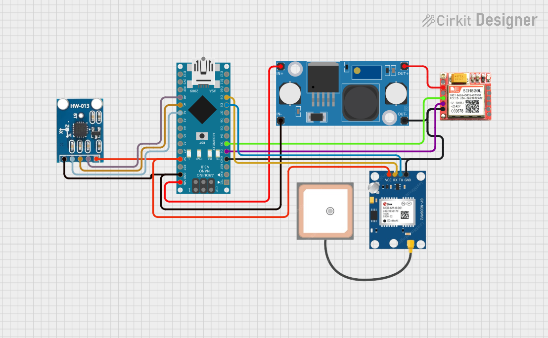
Example: Connecting GNSS L86 to Arduino UNO

Below is an example of how to interface the GNSS L86 with an Arduino UNO using UART communication.

Circuit Connections

GNSS L86 Pin Arduino UNO Pin
VCC 3.3V
GND GND
TXD Pin 10 (RX)
RXD Pin 11 (TX)
ANT_IN External Antenna

Arduino Code Example

#include <SoftwareSerial.h>

// Define RX and TX pins for SoftwareSerial
SoftwareSerial GNSS(10, 11); // RX = Pin 10, TX = Pin 11

void setup() {
  Serial.begin(9600); // Initialize Serial Monitor
  GNSS.begin(9600);   // Initialize GNSS module communication
  
  Serial.println("GNSS L86 Module Test");
}

void loop() {
  // Check if data is available from the GNSS module
  if (GNSS.available()) {
    // Read data from GNSS module and send it to Serial Monitor
    while (GNSS.available()) {
      char c = GNSS.read();
      Serial.print(c);
    }
  }
}

Troubleshooting and FAQs

Common Issues and Solutions

  1. No Satellite Fix:

    • Cause: Poor antenna placement or obstruction.
    • Solution: Place the antenna in an open area with a clear view of the sky.
  2. No Data Output:

    • Cause: Incorrect UART/I2C configuration.
    • Solution: Verify the baud rate (default: 9600) and ensure proper wiring.
  3. High Power Consumption:

    • Cause: Module operating in high-performance mode.
    • Solution: Use power-saving modes if supported by your application.
  4. Intermittent Signal Loss:

    • Cause: Electromagnetic interference or weak signal.
    • Solution: Shield the module from interference and use a high-gain antenna.

FAQs

Q1: Can the GNSS L86 operate without an external antenna?
A1: No, the GNSS L86 requires an external active antenna for optimal performance.

Q2: What is the default communication protocol?
A2: The default communication protocol is UART with a baud rate of 9600.

Q3: Can the module be used indoors?
A3: While the module can operate indoors, signal reception may be significantly degraded. Use it in open areas for best results.

Q4: How can I reduce power consumption?
A4: Implement power-saving modes and ensure the module is only active when needed.