How to Use StratologgerCF: Examples, Pinouts, and Specs
Introduction
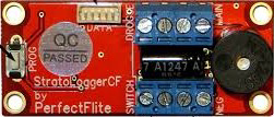
The StratologgerCF is a compact, lightweight data logger specifically designed for high-altitude ballooning, rocketry, and other aerial applications. It is capable of recording critical environmental data such as altitude, temperature, and pressure, making it an essential tool for flight analysis and recovery operations. Its robust design and high precision make it suitable for both hobbyists and professionals in aerospace and atmospheric research.
Explore Projects Built with StratologgerCF

Explore Projects Built with StratologgerCF
Common Applications and Use Cases
- High-altitude ballooning for atmospheric research
- Model rocketry for flight performance analysis
- Environmental monitoring in aerial platforms
- Recovery assistance for aerial payloads
- Educational projects in aerospace and physics
Technical Specifications
The StratologgerCF is engineered to deliver reliable performance in demanding environments. Below are its key technical details:
General Specifications
| Parameter | Value |
|---|---|
| Dimensions | 2.0" x 0.9" x 0.5" (50 x 23 x 13 mm) |
| Weight | 9 grams |
| Operating Voltage | 3.7V to 12V DC |
| Current Consumption | 5 mA (typical) |
| Altitude Range | 0 to 100,000 feet (0 to 30,480 meters) |
| Temperature Range | -40°C to +85°C |
| Data Storage Capacity | Up to 16 flights |
| Sampling Rate | 20 Hz |
Pin Configuration and Descriptions
The StratologgerCF features a simple pinout for easy integration into circuits:
| Pin Number | Pin Name | Description |
|---|---|---|
| 1 | VCC | Power input (3.7V to 12V DC) |
| 2 | GND | Ground connection |
| 3 | ARM | Arming switch input |
| 4 | CONTINUITY | Continuity check output for deployment circuits |
| 5 | DEPLOY1 | Output for primary deployment event (e.g., parachute release) |
| 6 | DEPLOY2 | Output for secondary deployment event |
| 7 | TX | Serial data output (for telemetry or data logging) |
| 8 | RX | Serial data input (for configuration or commands) |
Usage Instructions
The StratologgerCF is straightforward to use and can be integrated into a variety of aerial systems. Follow the steps below to ensure proper operation:
Basic Setup
- Power Connection: Connect the VCC pin to a power source (3.7V to 12V DC) and the GND pin to ground.
- Arming: Use a switch or jumper to connect the ARM pin to ground. This arms the device for flight.
- Deployment Outputs: Connect DEPLOY1 and DEPLOY2 pins to the respective deployment circuits (e.g., ejection charges or parachute mechanisms).
- Telemetry: Use the TX and RX pins to interface with a microcontroller or computer for real-time data logging or configuration.
Important Considerations
- Ensure the power supply is stable and within the specified voltage range to avoid damage.
- Mount the StratologgerCF securely to minimize vibrations during flight.
- Perform a ground test to verify deployment circuits and continuity before flight.
- Use the serial interface to configure parameters such as deployment altitude thresholds.
Example: Connecting to an Arduino UNO
The StratologgerCF can be connected to an Arduino UNO for data logging and configuration. Below is an example of how to read altitude data via the serial interface:
#include <SoftwareSerial.h>

// Define RX and TX pins for communication with StratologgerCF
SoftwareSerial stratologgerSerial(10, 11); // RX = pin 10, TX = pin 11

void setup() {
  Serial.begin(9600); // Initialize serial monitor
  stratologgerSerial.begin(9600); // Initialize StratologgerCF communication

  Serial.println("StratologgerCF Data Logger Initialized");
}

void loop() {
  // Check if data is available from StratologgerCF
  if (stratologgerSerial.available()) {
    String data = stratologgerSerial.readStringUntil('\n'); // Read data line
    Serial.println("Altitude Data: " + data); // Print data to serial monitor
  }

  delay(100); // Small delay to avoid overwhelming the serial buffer
}
Notes:
- Ensure the RX and TX pins on the Arduino are connected to the TX and RX pins on the StratologgerCF, respectively.
- Use a level shifter if the Arduino operates at 5V logic levels to avoid damaging the StratologgerCF.
Troubleshooting and FAQs
Common Issues and Solutions
No Data Output:
- Ensure the TX and RX pins are correctly connected.
- Verify that the StratologgerCF is powered and armed.
- Check the baud rate (default is 9600 bps).
Deployment Circuits Not Activating:
- Confirm continuity using the CONTINUITY pin.
- Verify that the deployment thresholds are correctly configured via the serial interface.
Device Not Powering On:
- Check the power supply voltage (must be between 3.7V and 12V).
- Inspect connections for loose wires or shorts.
Inaccurate Altitude Readings:
- Ensure the device is mounted securely to minimize vibrations.
- Avoid placing the StratologgerCF in areas with obstructed airflow.
FAQs
Q: Can the StratologgerCF be used in extreme weather conditions?
A: Yes, the device operates reliably in temperatures ranging from -40°C to +85°C.
Q: How do I reset the flight data?
A: Use the serial interface to send a reset command or clear the memory via the configuration software.
Q: Can I use the StratologgerCF for underwater applications?
A: No, the StratologgerCF is not waterproof and is designed for aerial use only.
Q: What is the maximum altitude the StratologgerCF can measure?
A: The device can measure altitudes up to 100,000 feet (30,480 meters).
By following this documentation, users can effectively integrate and operate the StratologgerCF in their aerial projects.