How to Use Quectel L96 : Examples, Pinouts, and Specs
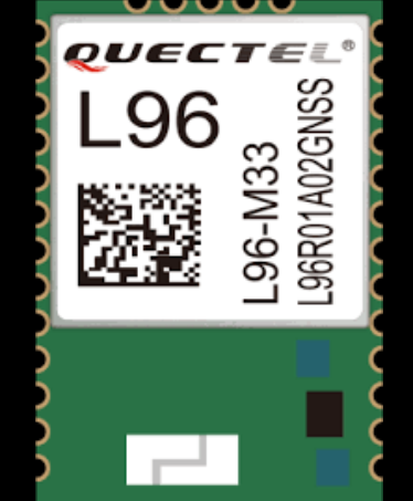
Quectel L96 GNSS Module Documentation
1. Introduction
The Quectel L96 is a high-performance GNSS (Global Navigation Satellite System) module designed to provide precise positioning and navigation capabilities. It supports multiple satellite systems, including GPS, GLONASS, Galileo, and BeiDou, ensuring robust and reliable location data in various environments. With its low power consumption, compact size, and high sensitivity, the L96 is ideal for applications in IoT devices, asset tracking, wearables, drones, and automotive systems.
Key Features:
- Multi-GNSS support: GPS, GLONASS, Galileo, and BeiDou.
- High sensitivity for weak signal environments.
- Ultra-low power consumption for battery-powered applications.
- Compact design for space-constrained devices.
- Built-in low-noise amplifier (LNA) for improved signal reception.
2. Technical Specifications
The following table outlines the key technical specifications of the Quectel L96 module:
| Parameter | Specification |
|---|---|
| Satellite Systems | GPS, GLONASS, Galileo, BeiDou |
| Frequency Bands | L1: 1575.42 MHz (GPS, Galileo, QZSS), 1602 MHz (GLONASS), 1561.098 MHz (BeiDou) |
| Position Accuracy | 1.8 meters CEP (50%) |
| Acquisition Sensitivity | -148 dBm |
| Tracking Sensitivity | -167 dBm |
| Cold Start Time | < 35 seconds |
| Hot Start Time | < 1 second |
| Supply Voltage | 2.8V to 4.3V |
| Power Consumption | 18 mA (tracking mode), 1.6 mA (standby mode) |
| Operating Temperature | -40°C to +85°C |
| Dimensions | 16.0 mm × 12.2 mm × 2.3 mm |
| Interface | UART, I2C |
Pin Configuration
The Quectel L96 module has a total of 12 pins. The table below describes the pin configuration:
| Pin Number | Pin Name | Description | I/O | Voltage Level |
|---|---|---|---|---|
| 1 | VCC | Power supply input | Input | 2.8V to 4.3V |
| 2 | GND | Ground | - | - |
| 3 | TXD | UART transmit data | Output | 2.8V |
| 4 | RXD | UART receive data | Input | 2.8V |
| 5 | 1PPS | 1 Pulse Per Second output | Output | 2.8V |
| 6 | SDA | I2C data line | I/O | 2.8V |
| 7 | SCL | I2C clock line | Input | 2.8V |
| 8 | V_BCKP | Backup power supply for RTC | Input | 2.0V to 4.3V |
| 9 | ANT_IN | RF signal input from external antenna | Input | - |
| 10 | RESET_N | Reset input (active low) | Input | 2.8V |
| 11 | NC | Not connected | - | - |
| 12 | NC | Not connected | - | - |
3. Usage Instructions
Connecting the L96 to an Arduino UNO
The Quectel L96 can be easily interfaced with an Arduino UNO using its UART interface. Below is a step-by-step guide:
Hardware Connections:
- Connect the VCC pin of the L96 to the 3.3V or 5V pin of the Arduino UNO.
- Connect the GND pin of the L96 to the GND pin of the Arduino UNO.
- Connect the TXD pin of the L96 to the RX pin (pin 0) of the Arduino UNO.
- Connect the RXD pin of the L96 to the TX pin (pin 1) of the Arduino UNO.
- If using an external antenna, connect it to the ANT_IN pin.
Software Setup:
- Install the Arduino IDE on your computer.
- Use the
SoftwareSeriallibrary to communicate with the L96 module.
Sample Code: Below is an example Arduino sketch to read GNSS data from the L96 module:
#include <SoftwareSerial.h> // Define RX and TX pins for SoftwareSerial SoftwareSerial GNSS(10, 11); // RX = pin 10, TX = pin 11 void setup() { Serial.begin(9600); // Initialize Serial Monitor GNSS.begin(9600); // Initialize GNSS module communication Serial.println("Quectel L96 GNSS Module Test"); } void loop() { while (GNSS.available()) { char c = GNSS.read(); // Read data from GNSS module Serial.print(c); // Print GNSS data to Serial Monitor } }Note: The GNSS module outputs NMEA sentences (e.g.,
$GPGGA,$GPRMC) by default. These sentences contain positioning and timing data.
Important Considerations:
- Use a level shifter if interfacing the L96 with a 5V microcontroller to avoid damaging the module.
- Ensure a clear view of the sky for optimal satellite reception.
- Use an external active antenna for better signal quality in weak signal environments.
- Connect the V_BCKP pin to a backup battery to retain RTC data during power loss.
4. Troubleshooting and FAQs
Common Issues and Solutions
| Issue | Possible Cause | Solution |
|---|---|---|
| No data output from the module | Incorrect wiring or baud rate mismatch | Verify connections and ensure the baud rate is set to 9600. |
| Poor satellite signal or no fix | Obstructed view of the sky or weak antenna | Move to an open area or use an external active antenna. |
| Module not powering on | Insufficient power supply | Ensure the power supply voltage is within the 2.8V to 4.3V range. |
| Data is garbled or unreadable | UART communication issue | Check the TX/RX connections and ensure proper voltage levels. |
| RTC data lost after power cycle | V_BCKP pin not connected to backup battery | Connect a backup battery to the V_BCKP pin. |
Frequently Asked Questions (FAQs)
What is the default baud rate of the L96 module?
- The default baud rate is 9600 bps.
Can the L96 module work indoors?
- The L96 is highly sensitive and may work indoors near windows, but for best results, use it outdoors with a clear view of the sky.
Does the L96 support DGPS or SBAS?
- Yes, the L96 supports DGPS (Differential GPS) and SBAS (Satellite-Based Augmentation System) for improved accuracy.
What type of antenna should I use with the L96?
- Use an active antenna with a gain of 15-25 dB for optimal performance.
How do I parse NMEA sentences from the L96?
- Use libraries like
TinyGPS++orNeoGPSin Arduino to parse NMEA sentences and extract useful data.
- Use libraries like
This documentation provides a comprehensive guide to using the Quectel L96 GNSS module. For further details, refer to the official Quectel L96 datasheet or contact Quectel technical support.
Explore Projects Built with Quectel L96
Explore Projects Built with Quectel L96